
“Supermap” to track bird flu
An interactive “supermap” that portrays the mutations and spread of the avian flu around the globe has been created.
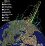
Scientists have designed a new interactive map of the spread of avian influenza (H5N1) that incorporates genetic, geographic and evolutionary information. Over time, this map should help researchers and policy makers better understand the avian virus and anticipate further outbreaks.
Researchers from University of Colorado and Ohio State University have used data from the known evolution and spread of the avian flu to create a roadmap of viral spread in time and space. The team projected genetic and geographic information onto an interactive globe using Google Earth technology. This allows users to fly virtually around the planet and analyse movements and changes in the genomes, or genetic blueprints, of known avian flu sub-strains that have been sequenced since the virus was first detected in China in 1996.
New, quick, easy
“This is a completely new method of integrating and sharing knowledge about disease spread, giving people a quick and easy way to make sense of the changes,” said graduate student Andrew Hill, a study co-author and chief architect of the visualisation portion of the research project.
A team of biomedical experts, led by Daniel Janies, an assistant professor in the department of biomedical informatics at Ohio State University, used special software to create an evolutionary tree of the virus’s mutations.
“The map gives us a whole new way of seeing the virus in action and understanding what it is – and isn’t – doing,†says Janies. “It’s enabled us to compare findings about viruses in the real world against pre-existing hypotheses about the spread of H5N1 that come from laboratory studies.â€
Related links:
Join 31,000+ subscribers
Subscribe to our newsletter to stay updated about all the need-to-know content in the poultry sector, three times a week.


 Beheer
 WP Admin
  Bewerk bericht